Iceland, a gem among the five Nordic countries, is steeped in Viking legends and Nordic charm. Its breathtaking scenery includes the awe-inspiring Geysir, the slumbering Katla volcano brimming with immense energy, the soothing Blue Lagoon ( Iceland's most worthwhile thermal experience ), the awe-inspiring Gullfoss waterfall, and the deep, mysterious Fjaðrárgljúfur canyon ( one of Iceland's nine must-see canyons )... Among Iceland's many beautiful landscapes, its mountains are equally dazzling, such as the towering Eyjafjallajökull volcano and the serene Vatnajökull glacier ( introduction to Iceland's four major glaciers ). These mountains were formed by various factors: tectonic activity, volcanic eruptions, glacial erosion, wind and rain, and temperature variations. This article will provide a detailed introduction to eight famous Icelandic mountains, including their historical background, topographical features, transportation options, and photography tips.
Whether you choose a self -drive package that allows for greater autonomy or a guided tour of Iceland's stunning mountains, both are excellent options when visiting Iceland.
East Iceland
1. West Horn of Iceland: Vestrahorn
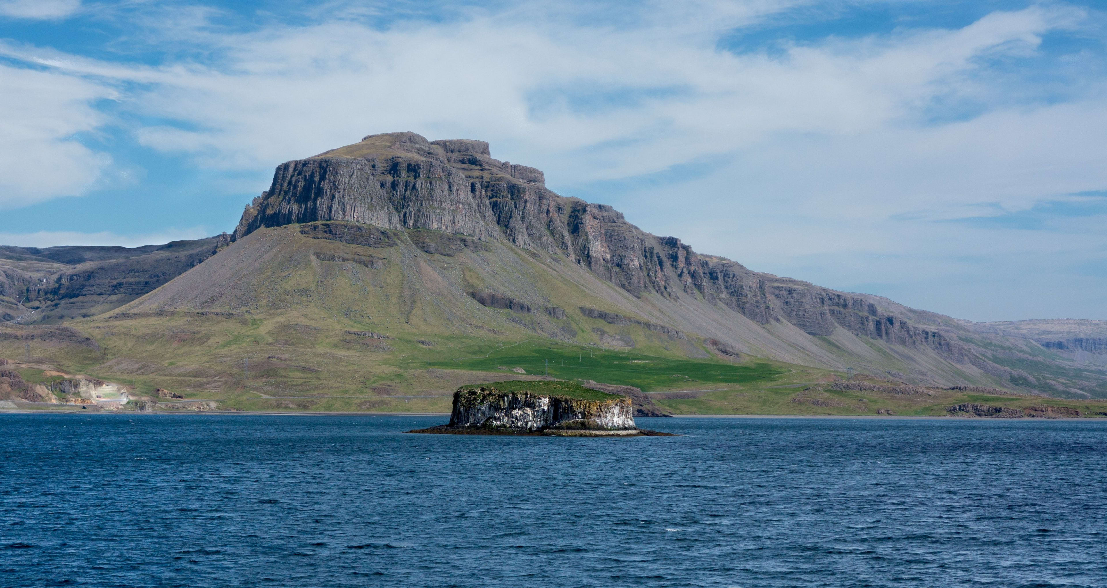
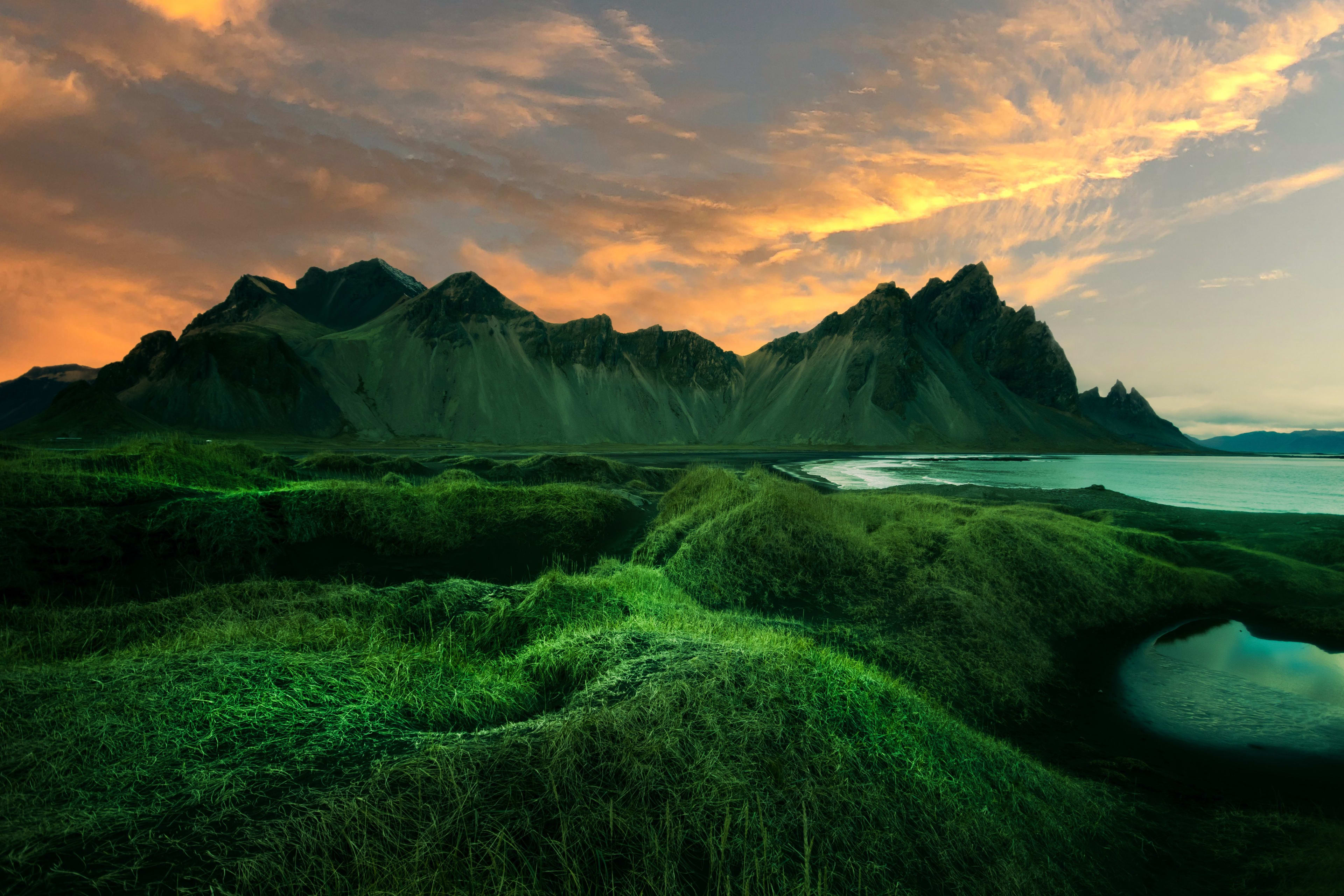
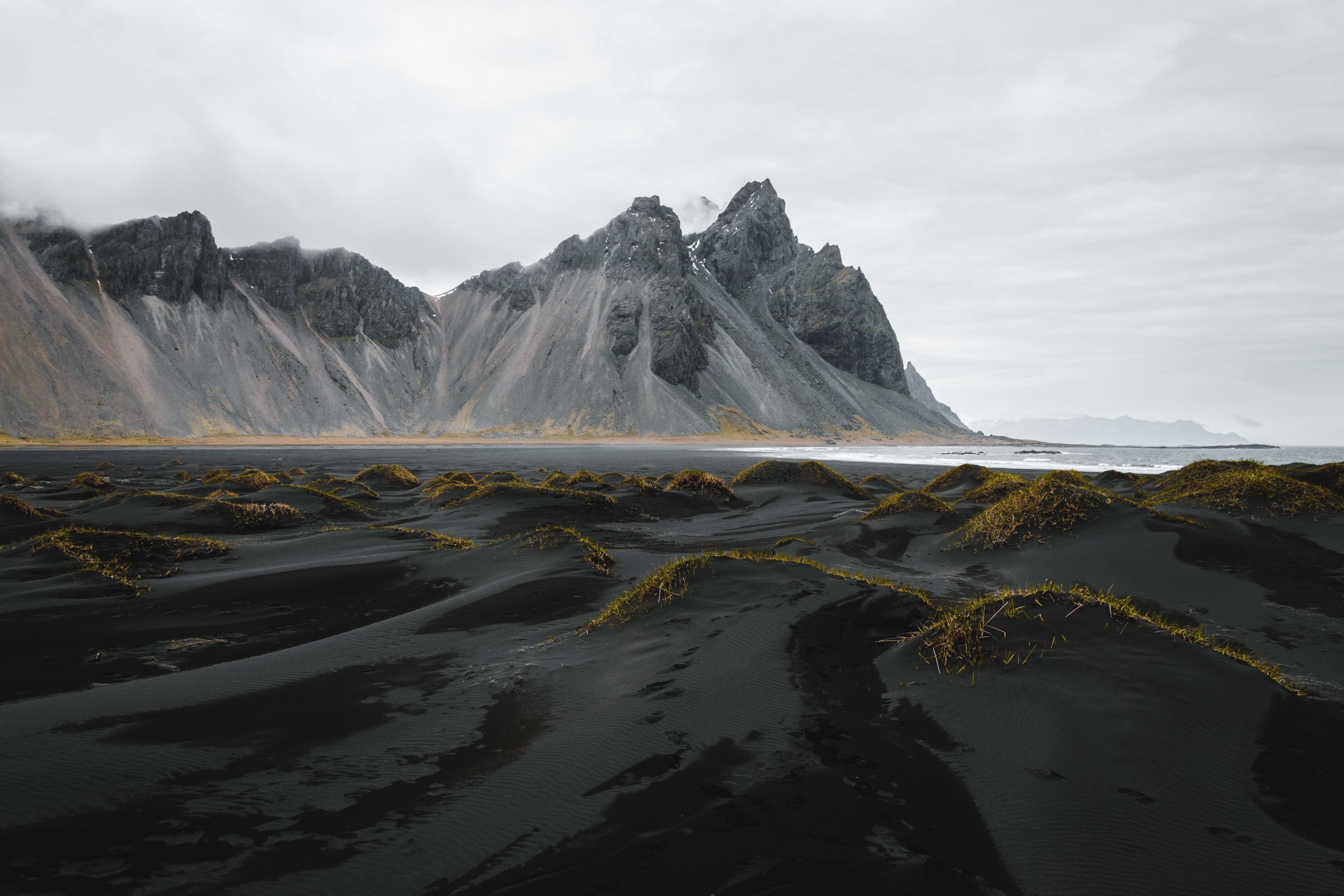
Vestrahorn, located on Iceland’s southeast coast near the town of Höfn , is a popular spot for photographers due to its steep ridges, uniquely shaped rocks, wetlands, and black sand beaches.
Vestrahorn, meaning "West Horn," derives its name from its geographical location—located at the southeastern tip of Iceland, facing the Atlantic Ocean. Geographers speculate that Vestrahorn was likely formed by the interaction of glacial and volcanic activity. The mountain is extremely steep, with sharp peaks; from a distance, its ridges spread outwards, resembling a bat with outstretched wings, flying towards the viewer. Therefore, Vestrahorn is often called "Bat Mountain." At the foot of Vestrahorn lies a vast black sand beach and wetlands. The black sand beach, formed by volcanic eruptions, is a striking contrast to the mountain's color. Puddles and small lakes often gather on the black sand beach, their surfaces reflecting the mountain like mirrors, creating a dreamlike scene. The area around the mountain is rich in wildlife, especially in spring and autumn when the vegetation around the wetlands is lush, with tundra plants and wildflowers blooming, creating a vibrant atmosphere. In winter, Vestrahorn is covered in snow and ice, with a chilling wind blowing, possessing a desolate and cold beauty.
mode of transportation
West Point is about 11 kilometers from the town of Hofn, making it easily accessible from the town. If you're starting from Reykjavík ( Reykjavík day trip guide ), drive east along Ring Road 1, passing through Vík and Hofn, to reach West Point. Parking is near the foot of the mountain; you can park and hike up. While a regular sedan is fine for driving, a four-wheel drive vehicle is recommended for exploring the surrounding wetlands and black sand beaches. ( Iceland Driving Guide )
Shooting Techniques
The best time to photograph West Point Mountain is during sunrise or sunset, when the light is soft and avoids harsh glare that could affect the image's depth. At sunset, the light outlines the mountain ridges, and the black sand beach reflects West Point Mountain's image. You can stand by the black sand beach and use the water's surface to capture the mountain's reflection. For panoramic views of the mountain range, black sand beach, and surrounding scenery, a wide-angle lens is recommended to capture the expansive landscape. In winter, long exposures can be used to capture the aurora borealis at West Point Mountain.
2. Europe's largest glacier: Vatnajökull
Vatnajökull, located in southeastern Iceland, is part of Iceland National Park ( Iceland National Park: Experience the Beauty of Nature and Culture ). Vatnajökull is the largest glacier in Europe, witnessing thousands of years of Icelandic weathering. Iceland lies at the boundary of the Eurasian and North American tectonic plates, experiencing frequent crustal movements that have created a wealth of geological wonders. Vatnajökull is a product of volcanic eruptions and cooling processes; beneath the glacier lie several active volcanoes, such as Grímsvötn and Bárðarbunga.
For the Icelandic people, Vatnajökull glacier is not only a gift of nature but also a sacred place. In Icelandic traditional stories, "glacier giants" guard this frozen mountain range. These giants both deter those who disrespect the glacier and protect travelers who are filled with awe, allowing them to safely traverse the glacier.
In winter, the ice caves of Vatnajökull Glacier are a popular tourist destination. Under the frigid conditions, blue icicles and passageways form inside the caves, and sunlight filtering through the ice refracts into a dreamy blue glow. However, the ice caves are not static; their shape and size change with the seasons, making each visit to a blue ice cave a unique and unforgettable experience.
Jökulsárlón, located at the southern end of Vatnajökull Glacier, is one of Iceland's most famous glacial lagoons. The lagoon is dotted with ice blocks of various shapes, some blue and some white, creating a striking contrast with the surrounding black sand beaches, resulting in a truly unique landscape.
mode of transportation
Driving is the best way to get to Vatnajökull Glacier. From Reykjavik, the capital of Iceland, drive southeast along Ring Road (Route 1), which takes about 5 hours. If you don't want to drive, you can join a local glacier and volcano tour or a day tour of Iceland . Many Icelandic tours offer various Vatnajökull Glacier tours, such as glacier hiking ( Exploring the Wonders of Ice: A Complete Guide to Glacier Hiking in Iceland ), ice cave exploration ( Ice Cave Exploration Guide to Experience Glacier Wonders in Iceland ), and off-road vehicle tours. For more flexibility, you can choose a private car service, which is perfect for families or groups. Private car services can provide personalized itineraries and help you avoid peak tourist seasons.
Related itineraries: Skafta Glacier hike , blue ice cave exploration
Arrive in East Iceland! An 11-day summer road trip around the island, including the Eastfjords and whale watching, will satisfy your needs!
Shooting Techniques
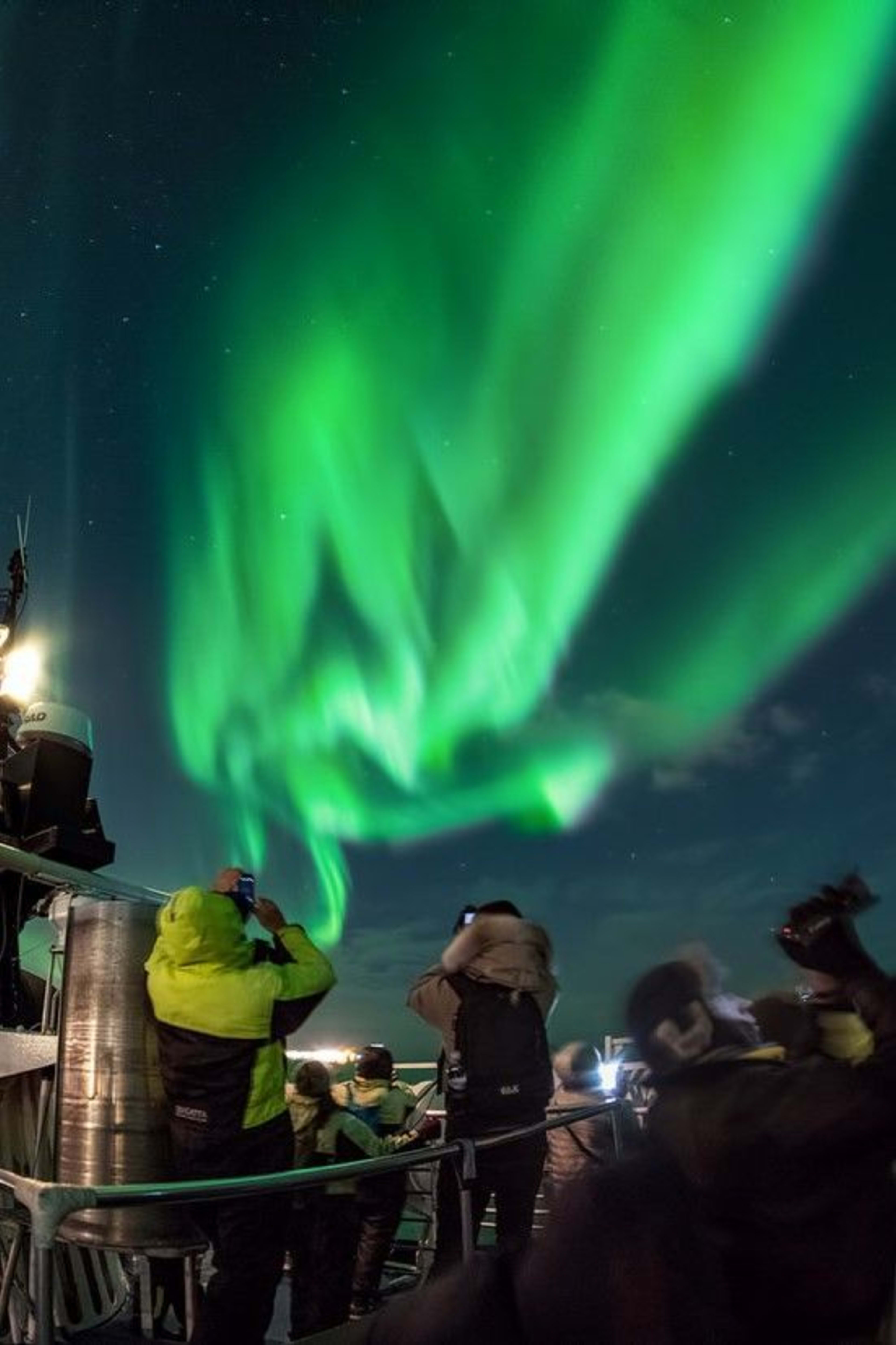
The best time to photograph Vatnajökull Glacier is in winter, when the ice caves beneath the glacier take on a deep, mesmerizing blue hue. During the polar night, there's also a chance to capture the aurora borealis ( see the complete guide to aurora viewing in Iceland). Using a lower ISO (e.g., ISO 800-1600), combined with a wide aperture and a longer exposure time, you can capture sharp images of the aurora. Vatnajökull Glacier is vast and well-suited for wide-angle lenses. Beside the glacial lagoon, you can try capturing panoramic views of floating icebergs. Weather permitting, try long exposures to photograph the effect of icebergs drifting in Jökulsárlón glacial lagoon. Long exposures are also great for capturing the flow of rivers, adding a sense of dynamism to your photos. When shooting inside ice caves, due to the dim lighting, it's recommended to use a higher shutter speed and a higher ISO to capture the transparent texture of the ice.
West Iceland
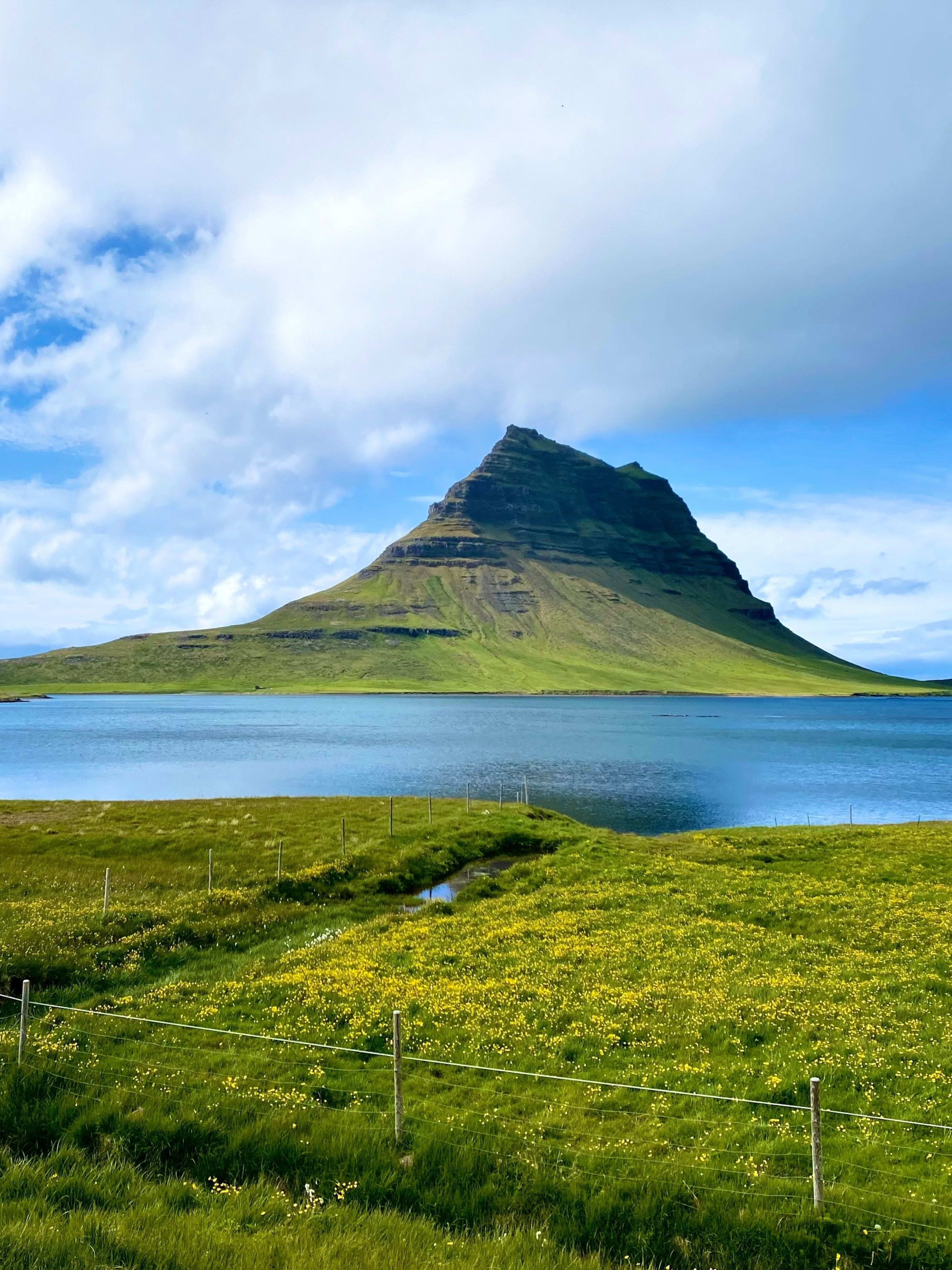
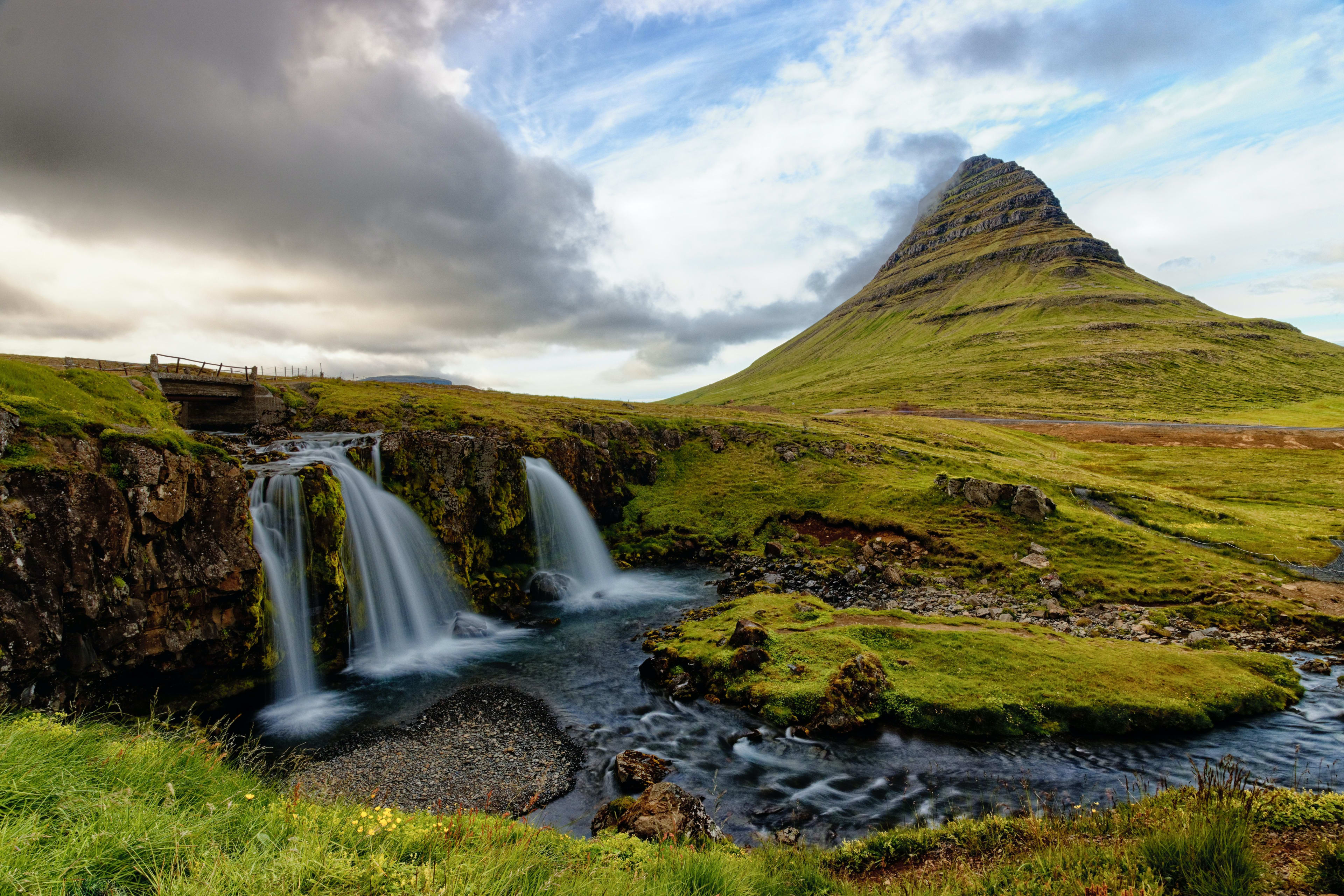
1. Iceland's sacred mountain: Kirkjufell
Kirkjufell, located on the Snæfellsnes Peninsula in western Iceland (Iceland in a Nutshell – A Comprehensive Guide to the Snæfellsnes Peninsula ), is one of Iceland's most iconic mountains. Its unique shape resembles a sombrero, hence its nickname "The Sombrero." The villages surrounding Kirkjufell were early missionary sites for Christianity, where villagers frequently visited the foot of the mountain to pray for divine protection. Later, with the widespread dissemination of Christianity, Kirkjufell gradually became a religious symbol of Iceland. Legend has it that Kirkjufell is a sacred mountain in Icelandic mythology, considered a path to the divine realm, and many locals believe it possesses magical powers, bringing good fortune and protection.

At the foot of Church Mountain lies Kirkjufellsfoss , a waterfall with crystal-clear water cascading down the mountain, forming several streams that create a stunning contrast with the mountain itself, making it a rare and beautiful subject for photography. Church Mountain is located in the heart of the Snæfellsnes Peninsula, surrounded by vast grasslands, lakes, and volcanic rock formations. From Church Mountain, you can also see another famous Icelandic mountain: Snæfellsjökull.
mode of transportation
Church Hill is about 200 kilometers from Reykjavik, the capital of Iceland, a drive of about 3 hours. If you're driving, you can start from Reykjavik and head west along Ring Road 1. Along the way, you'll pass through towns on the Snæfellsnes Peninsula. If time permits, you can stop and experience the unique charm of Icelandic towns like Borgarnes . While driving is the most convenient way to get to Church Hill, you can also join a tour if you don't have a car. There are parking lots near Church Hill, and you can hike there. Church Hill itself isn't very large, and you can reach all the nearby attractions on foot. If you plan to hike, it's recommended to start from Church Hill Waterfall, where there's a clearly marked trail. Following this trail will allow you to fully appreciate the unique scenery of Church Hill.
Shooting Techniques
The most classic angle for photographing Church Mountain is from the direction of Church Mountain Waterfall, with the waterfall in the foreground and the mountain peaks in the background. This is particularly suitable for long exposures, capturing the silky effect of the flowing water. Alternatively, a wide-angle lens can be used to include both the waterfall and the mountain peaks in the frame, highlighting Church Mountain's unique shape. In winter, if you stay nearby at night and are lucky enough, you can even photograph Church Mountain with the Northern Lights as a backdrop. ( The most comprehensive guide to observing the Northern Lights in Iceland )
2. The final resting place of a legendary hero: Helgafell.
Helgafell, a famous mountain in western Iceland, is located near the town of Ólafsvík at the northern tip of the Snæfellsnes Peninsula. It carries with it a rich history and culture, and is steeped in mysterious legends ( five of Iceland's most well-known folk tales ), making it one of the most mythical mountains in western Iceland. The mountain's name originates from an ancient Icelandic myth: Legend has it that the legendary hero Helgi fought in the Snæfellsnes Peninsula region, and Helgafell is his final resting place. Another Icelandic folklore tells of the summit of Helgafell as the dwelling place of ancient gods, where miracles occur at certain times, granting wishes to the devout. Therefore, Helgafell attracts numerous pilgrims and believers, making it one of Iceland's sacred sites.
Helge Hill, at approximately 455 meters, isn't particularly high, but its summit offers panoramic views of the surrounding landscape—the beautiful coastline of the Snæfellsnes Peninsula, the surging ocean, and the towering Snæfellsjökull volcano. On clear days, the summit is breathtaking, with the Atlantic Ocean, lush green meadows, and snow-capped mountains creating a serene and expansive vista. The natural environment surrounding Helge Hill remains largely untouched. At its foot, historical sites bear witness to the lifestyles of Iceland's early settlers, particularly their agricultural and pastoral practices. Archaeologists and historians conduct excavations and research here annually.
mode of transportation
Helge Hill is located in the northern part of the Snæfellsnes Peninsula, about 200 kilometers from Reykjavik, the capital of Iceland, approximately a 3-hour drive. From Reykjavik, take Ring Road 1, passing the town of Borganes, and continue west until you reach the town of Ålafsvik, where Helge Hill is located. For hiking, there are hiking trails available for Helge Hill; these are relatively easy, taking about 1 to 2 hours and suitable for hikers of varying fitness levels.
Shooting Techniques
赫尔格峰最佳拍摄角度是从山脚下的草原或湖泊方向拍摄,用水面或草地作为前景。如果想让赫尔格峰和斯奈菲尔火山同框,可以站在高处拍摄。赫尔格峰的山顶和周围的草地非常适合使用长时间曝光拍摄,尤其在拍摄瀑布和湖泊时,长曝光能让动态的水流和云彩与静态山体形成对比。
3. 地心入口:斯奈菲尔火山(Snæfellsjökull)
斯奈菲尔火山(Snæfellsjökull)位于冰岛斯奈山半岛的西端,是冰岛最具传奇色彩的自然地标之一,这座火山不仅有迤逦的景色,还颇具传奇色彩。斯奈菲尔火山有超七十万年的历史,是冰岛少数保存完好的锥形火山之一。火山喷发历史久远,最后一次喷发约在公元200年左右。如今的斯奈菲尔火山上覆盖着冰川,是冰岛境内少数几座被冰川覆盖的活火山之一。天气晴朗时,数百公里外就能看到火山的冰川顶,这也是斯奈山半岛的标志性景观。
如果您看过法国作家儒勒·凡尔纳的科幻小说《地心游记》,一定记得书中描绘了一支探险队从一座火山进入地球中心,这座火山就是斯奈菲尔火山,也正因如此,斯奈菲尔火山被称为“地心入口”,吸引了大量文学爱好者和科幻迷前来探访。此外,在当地传说中,这座火山还是个“能量中心”,蕴藏着神秘能量,有疗愈身心的作用。
想要加入探索地心的活动吗?斯奈山半岛Vatnshellir洞穴地心历险体验将带你目睹神奇的地质奇观。

斯奈菲尔火山周边有许多独特的火山岩和熔岩洞穴(识洞寻踪:探秘冰岛各大火山熔岩洞穴),包括 Lóndrangar 岩柱等,都是由火山喷发后的熔浆冷却形成。
交通方式
斯奈菲尔火山距首都雷克雅未克约150公里。从雷克雅未克出发,沿1号环岛公路向西行驶,约2小时就能到斯奈山半岛。到半岛后,可以继续沿54号公路行驶,跟随路标进入斯奈菲尔冰川国家公园。
拍摄技巧
用广角镜头拍摄,可以捕捉到冰川与天际线的层次感。如果想捕捉火山的细节,可以用远摄镜头拍冰面上的裂缝和纹理。冬季如果看到极光,可以在火山前低角度拍摄,将火山与极光同时纳入镜头,用三脚架和长曝光,也可以让极光更清晰。斯奈菲尔火山周围的火山岩地貌很独特,在Lóndrangar岩柱等地拍摄,可以用中焦距镜头捕捉火山岩的粗犷之美,同时可以用逆光效果,突出岩石的轮廓感。如果有条件,可以用无人机从高空拍摄斯奈菲尔火山的冰川景色,展现火山的粗犷之美和冰川的细腻纹理。这种视角尤其适合拍摄全景。
要想来斯奈山半岛见证这些奇妙山峰,可把斯奈山半岛一日游行程纳入安排。或者,最好的是,在环岛自驾途中前往这个神奇的半岛:
冰岛南部
1. 冰岛北极星:迈利费德火山 (Mælifell)
迈利费德火山(Mælifell)位于冰岛南部的米达尔斯冰川(Mýrdalsjökull)地区。Mælifell在冰岛语中有“测量之山”之意,主要因为冰岛人曾用这座山峰来确定方向和辨认气候变化。迈利费德火山还和冰岛的维京历史及神话传说相关,传闻这座山峰是火山神灵栖息的地方,山脚下流淌着圣水,古代冰岛居民常常到这里祭祀和祈祷。
迈利费德火山是一个典型的锥形火山山体,山体高约791米,山顶常年被白雪覆盖。它的形状在冰岛的山脉中独树一帜,经过数次火山喷发,火山岩浆和火山灰塑造着山峰的地貌,形成了独特的山脉轮廓。迈利费德火山也是冰岛南部最重要的冰川之一,山峰的景致四时各异,夏季时节成群的鸟类在这里栖息,附近的草原和湿地,也是许多野生动物的栖息地。
交通方式
迈利费德火山距首都雷克雅未克约200公里,驾车约3小时。如果自驾前往,可以从雷克雅未克出发,沿着1号环岛公路向东行驶,在霍尔斯沃德吕尔(Hvolsvöllur)左转驶入261号公路,然后驶入F261号公路,沿着索斯莫克自然保护区(Þórsmörk)一路向北行驶,右转驶入F210号公路,继续行驶就能看到迈利费德火山。自驾途中可以停下来欣赏周围的瀑布、黑沙滩和火山岩。需要注意,迈利费德火山的位置比较偏远,且部分道路不适合普通轿车通行,得开四驱车或者高地车前往。尤其在冬季,道路被冰雪覆盖,普通轿车很难保障安全。
拍摄技巧
迈利费德火山最推荐的拍摄角度是从山脚下的道路或周围的河流旁边拍摄。可以通过低角度拍摄,捕捉山体与周围景色。同时,还可以尝试从更远的高处拍摄,让迈利费德火山的全貌、周围冰川、火山地貌尽收眼底。
迈利费德火山的天气变化多端,云雾和光线变化可以提供别致的拍摄氛围和效果。比如天空突然变阴,山峰被云层笼罩,给照片增添一丝神秘感。
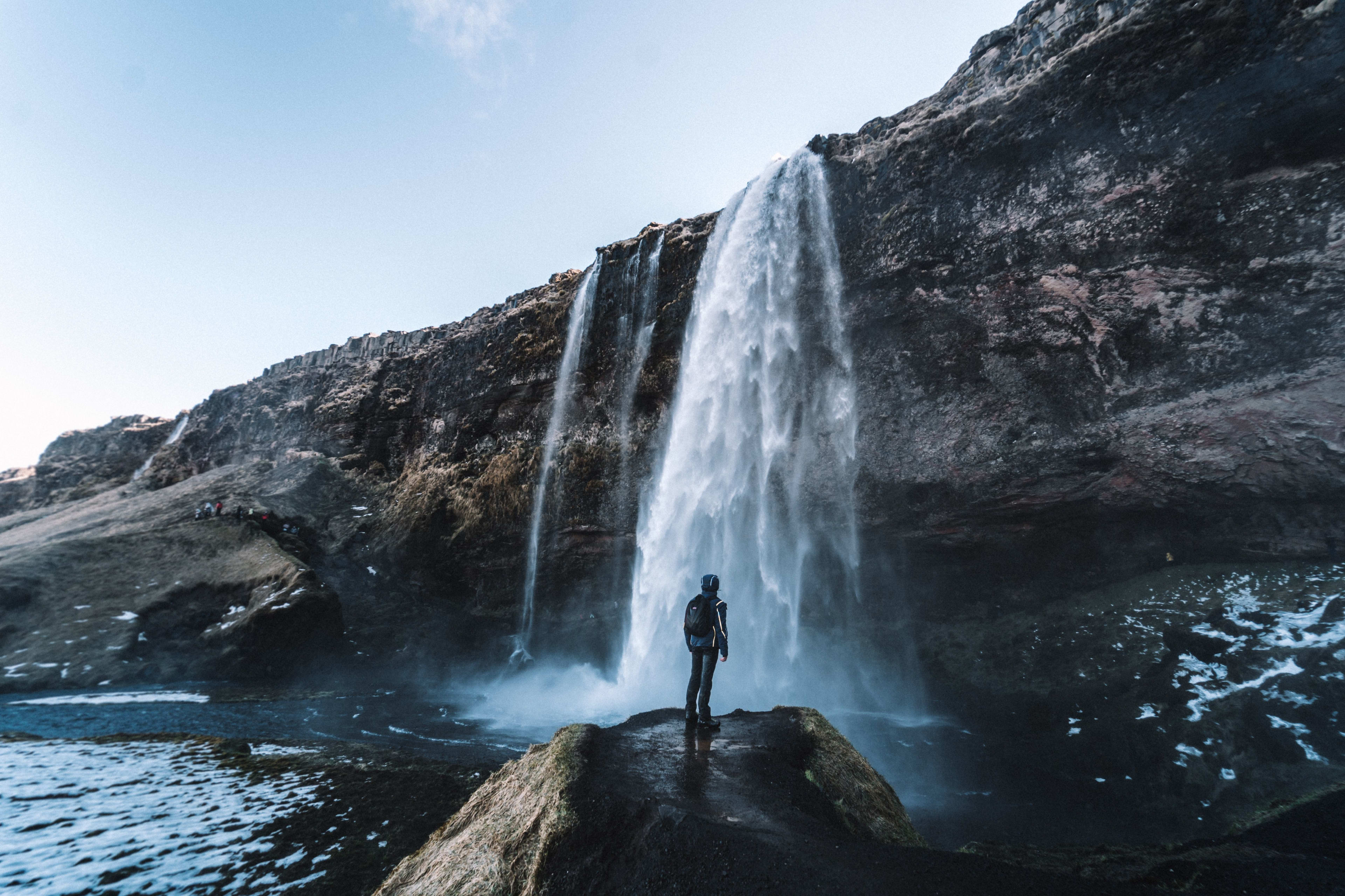
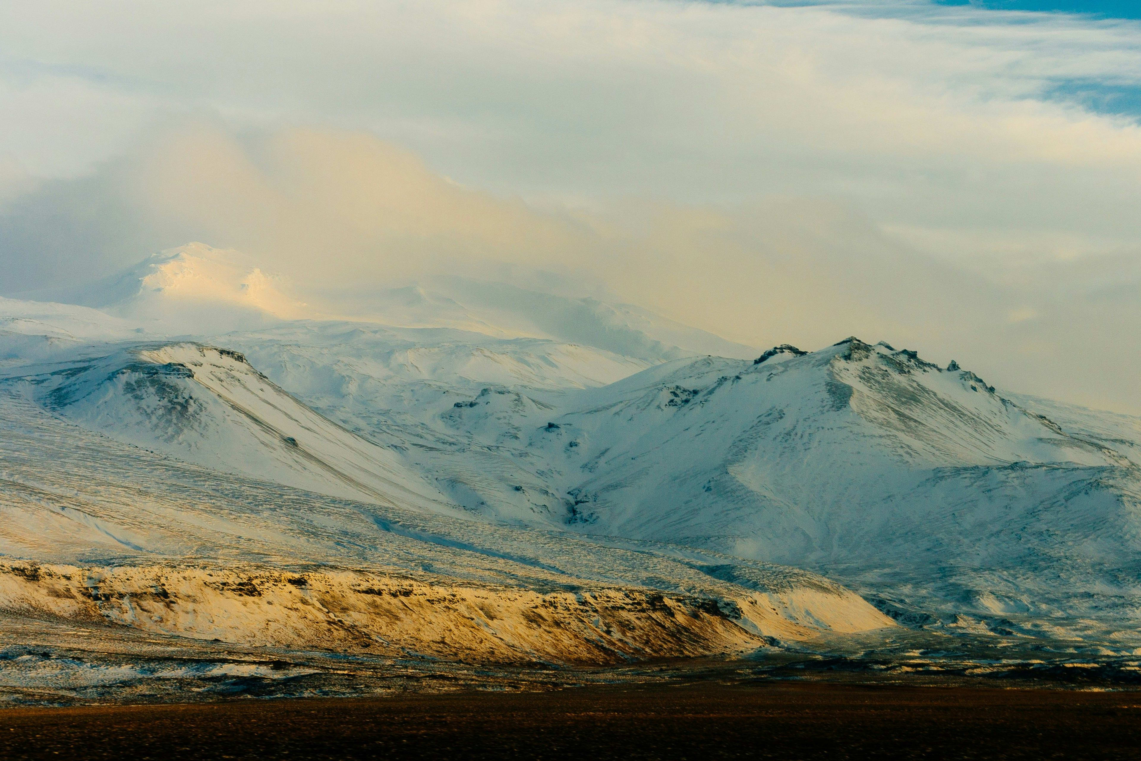
2. 冰与火之山:埃亚菲亚德拉火山(Eyjafjallajökull)
埃亚菲亚德拉火山(Eyjafjallajökull)位于冰岛南部,是冰岛最著名,最活跃的火山之一。埃亚菲亚德拉火山的历史并不久远,2010年,埃亚菲亚德拉火山曾喷发过一次,喷出的火山灰柱高达9000米,严重影响了冰岛的生态环境及航空交通,一时成为新闻焦点。这次火山喷发波及整个欧洲,许多机场因此关闭,大量航班停飞,航空交通几乎陷入瘫痪。
埃亚菲亚德拉火山的名字在冰岛语中可以分为三个部分,其中“Eyja”意为“海岛”,“Fjalla”是“山峰”的意思,而“Jökull”意为“冰川”。因此,这座山峰也可以被翻译为 “冰川覆盖的山峰”,这个名字很形象地描述了埃亚菲亚德拉火山的特征--山体被厚厚的冰川覆盖。
冰岛许多传说都与火山活动和自然灾害有关。当地人相信火山和冰川是神灵的居所,而火山喷发源自神灵的力量。埃亚菲亚德拉火山也不例外,传说这座火山曾是冰岛火焰女神的住所。
埃亚菲亚德拉火山不仅是活火山,也是一座冰川。冰川上的冰雪融化成潺潺流水流入山谷,冰川下火山活动频繁,经常出现熔岩流。埃亚菲亚德拉火山的喷发周期并不规律,科学家们一直在监测它的活动,火山周围有许多气势磅礴的瀑布,最著名的当属塞里雅兰瀑布(Seljalandsfoss),这条瀑布背后有一条通道,可以站在瀑布背后,看水流如帘幕一般从岩壁上倾泻而下,仿佛身临“花果山瀑布”。
交通方式
埃亚菲亚德拉火山距首都雷克雅未克约125公里,沿1号环岛公路向东行驶,约1.5到2小时的车程。因为埃亚菲亚德拉火山附近的地形较崎岖,尤其在天气恶劣时,道路泥泞,冰雪覆盖极易打滑,因此建议开四驱车或越野车。
拍摄技巧
埃亚菲亚德拉火山绝对是摄影好去处,不管是火山本身,还是周围的冰川和瀑布,都是绝佳拍摄素材。站在瀑布前面,可以用长曝光拍摄瀑布的水流效果,用火山和冰川作为背景。火山周围的自然环境也很适合摄影,尤其是春夏季,苔原和野花在火山岩中生长,生机勃勃,和深色的火山岩对比鲜明。
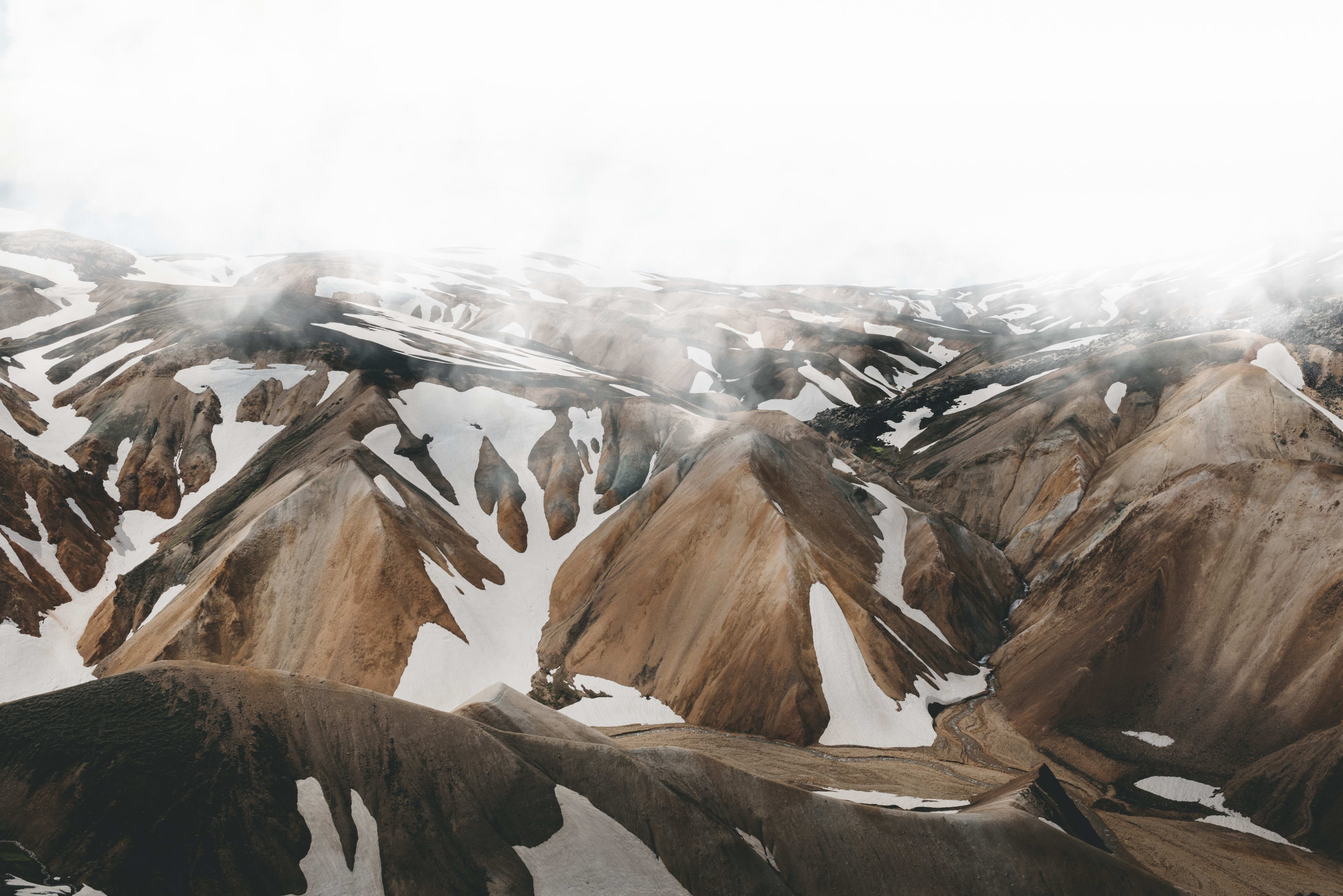
4. 冰岛温泉鼻祖:兰德曼纳劳卡山(Landmannalaugar)
兰德曼纳劳卡山(Landmannalaugar)位于冰岛南部内陆高地地区,有独特的地热景观、五彩斑斓的山脉、温泉、丰富的徒步路线,是冰岛最著名的自然保护区之一。兰德曼纳劳卡山在冰岛的地质和文化历史上占据重要地位,它的名字源自冰岛的“Landmann”一词,在冰岛语中意为“移民”或“定居者”,据传,冰岛早期定居者和探险者曾在这儿的温泉中洗澡,因此,这个地方也被称为“人类的洗浴地”。
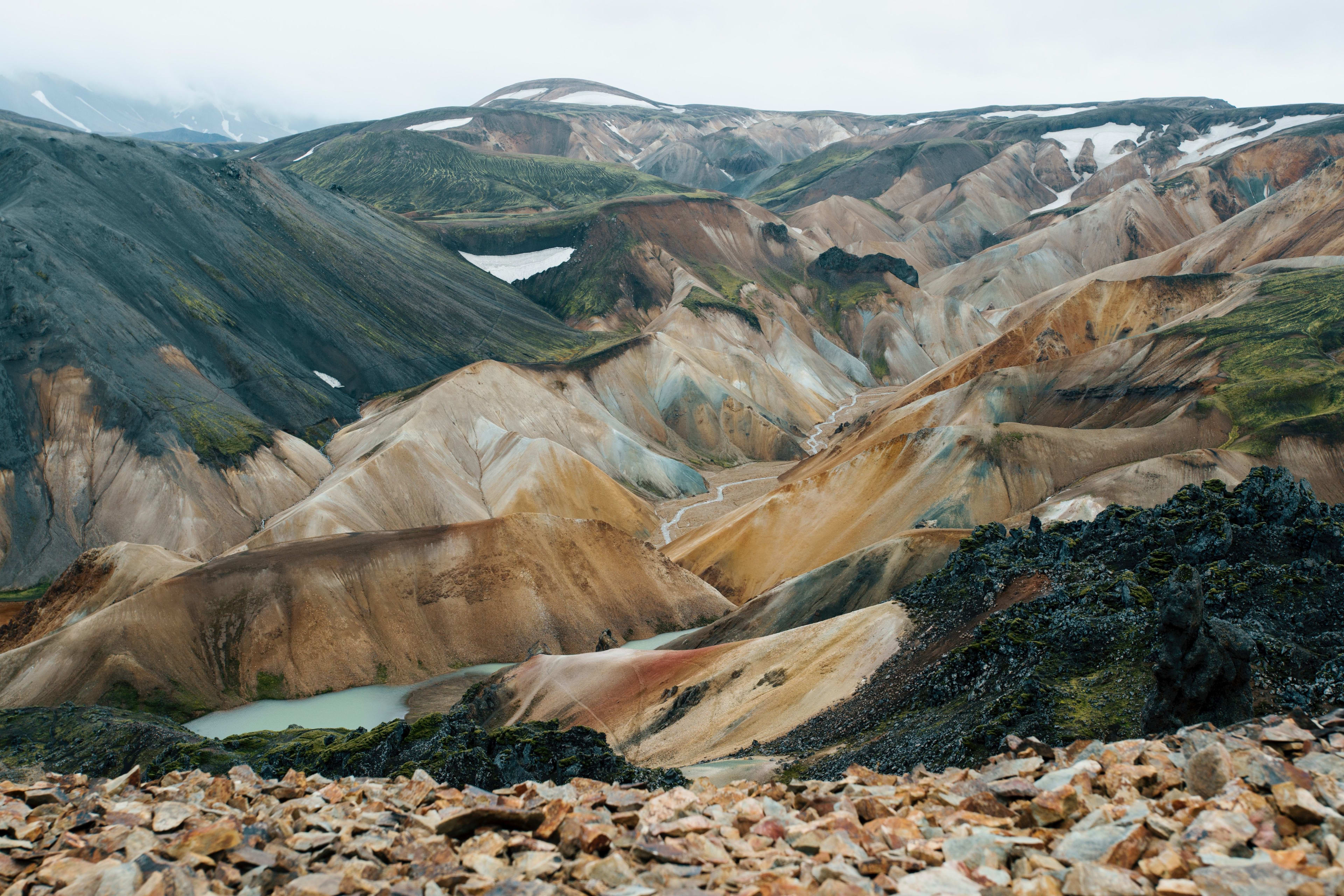
火山和地热活动塑造了兰德曼纳劳卡山(热能涌动的冰岛:探秘冰岛地热奇观),这里地质结构多样,熔岩流、火山灰、硫磺沉积以及火山岩,这些岩石色彩鲜艳,色调丰富,黄色、红色、绿色等颜色的岩石让山体色彩斑斓。受地热活动影响,兰德曼纳劳卡山内形成了天然温泉,这里的温泉水温适宜,水质清澈,适合边放松身体,边欣赏周边美丽的自然景色。
兰德曼纳劳卡山也是冰岛最著名的徒步探险地之一,其中最著名的徒步路线是Laugavegur(冰岛入门级徒步路线),这条路线连接了兰德曼纳劳卡山和索斯莫克,是冰岛最受欢迎的长途徒步路线之一,整个行程约55公里,沿途有火山、冰川、温泉。除此之外,兰德曼纳劳卡山周围还有其他短途徒步路线。山中的动植物也很多样,春夏两季,山间草地上会开满野花,引来鸟类和昆虫,给徒步增添不少意趣。
交通方式
兰德曼纳劳卡山位于冰岛的内陆高地地区,距离雷克雅未克有一定距离。从雷克雅未克出发,可以沿着1号环岛公路行驶,然后转入通往内陆高地的F225公路,继续行驶就能到兰德曼纳劳卡山。F225公路是F级公路(冰岛F级公路最全指南),几乎全程都是没有铺过的碎石路,需要开四驱车才能通行,当然,也可以坐高地巴士(Highland Bus)前往(专为前往内陆景区的游客开设)。要注意,冰岛内陆高地地区的开放时间是6月-8月,建议提前做好时间规划。根据冰岛环境局最新政策,如果自驾前往,要提前预订好停车位。
相关行程:兰德曼纳劳卡高地一日游
拍摄技巧
天气晴朗时,阳光照射在五彩斑斓的兰德曼纳劳卡山上,形成独特的光影效果,快门一按,就是一张绚丽的摄影作品。就季节来说,夏季是拍摄兰德曼纳劳卡山的最佳时段,因为此时山野间青草茵茵,野花盛放,为画面增色不少。兰德曼纳劳卡山适合广角镜头拍摄,这样可以捕捉山脉全貌和远处风景,也能更好呈现火山、岩层的细节。拍兰德曼纳劳卡山的温泉或溪流,也可以用长曝光。
5. 冰岛雷市附近可远眺:埃斯亚山/埃夏山(Esja)
埃斯亚山(Esja),也称埃夏山,位于冰岛首都雷克雅未克对岸,是极受欢迎的登山和徒步点。这座山是雷市的标志性景观,也是一道抵御强风的天然屏障,自然景观优美,交通也便携。埃斯亚山的历史可追溯至上个大冰期初季,当时山顶冰川覆盖,山底火山活动频繁,火山爆发释放的岩浆在冰川底部层层堆积,冷却凝固。后来随着冰川消退,底部凝固的山体渐渐浮出,形成了如今的山脉。埃斯亚山主要由玄武岩和凝灰岩构成,山体分层明显,宛如地质课本。从远处看,埃斯亚山像一座色彩缤纷的城堡,尤其在夕阳下,色彩配合着光影,美不胜收。埃斯亚山上植被茂盛,夏季时,鲁冰花和野花遍布山野。
埃斯亚山离雷克雅未克非常近,几乎可以在市区任何地方看到这座山,因此人们觉得埃斯亚山就像是雷克雅未克的守护天使。在埃斯亚山可以体验许多户外活动,比如登山和徒步。登上山顶,可以欣赏雷克雅未克和北大西洋的全景。夏季,山顶还会举办热闹的音乐会。埃斯亚山有两条著名登山路线,分别是Þverfellshorn路线和Steinn路线,Þverfellshorn路线是埃斯亚山最受欢迎的徒步路线,终点是海拔780米的Þverfellshorn观景点,Þverfellshorn路线部分路段较陡峭,需手脚并用攀爬,整体难度中等偏高,适合体力充沛,有一定经验的登山爱好者。Steinn路线的难度较低,终点是山腰处一块名为 “Steinn”(意为“岩石”)的标志性巨石,适合家庭游客和没有经验的登山爱好者。
交通方式
埃斯亚山距雷克雅未克约10公里,可以自驾或坐公交前往。自驾沿49号公路行驶,大约15分钟后转入1号环岛公路,不久就能看到埃斯亚山的登山入口。登山入口处有停车场、公共卫生间和信息板,信息板上记录了当天天气、徒步建议和不同路线的详细信息,方便游客了解。如果没有租车,可乘坐15路公交车,在rtn站换乘57路公交车,然后在Esjurtur-Hiking Center站下车。
拍摄技巧
埃斯亚山是拍雷克雅未克全景的好地方,站在Þverfellshorn观景点,可以用广角镜头把雷克雅未克和北大西洋的广阔海景一起收入镜头,日出或日落时,光影交错,更能出片。埃斯亚山层次分明,可以用色彩层叠的山体做背景,再以徒步的游客或山间小路做前景,拍摄出人与自然和谐相处的状态。如果想捕捉山脉的四季风光,夏季可以拍绿意盎然的山坡和蓝天,冬季可以用三脚架和滤镜捕捉山脉覆盖积雪时的冷色调美感。如果条件允许,可以用无人机从山顶俯瞰,拍摄山脉与海岸线相接的景观。
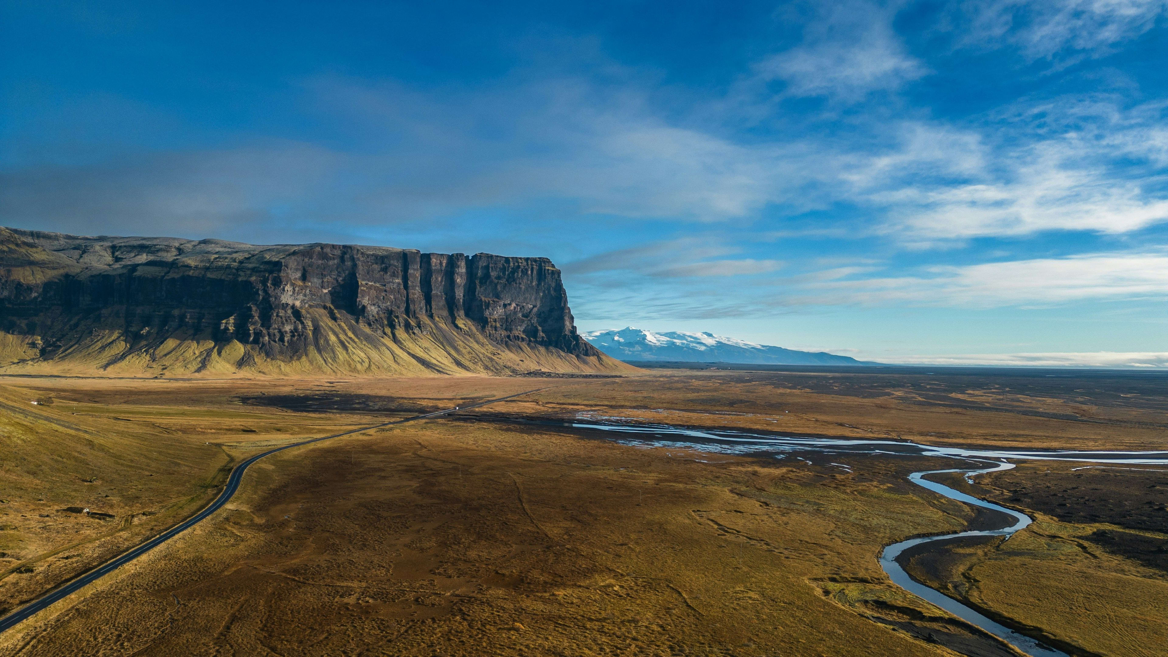
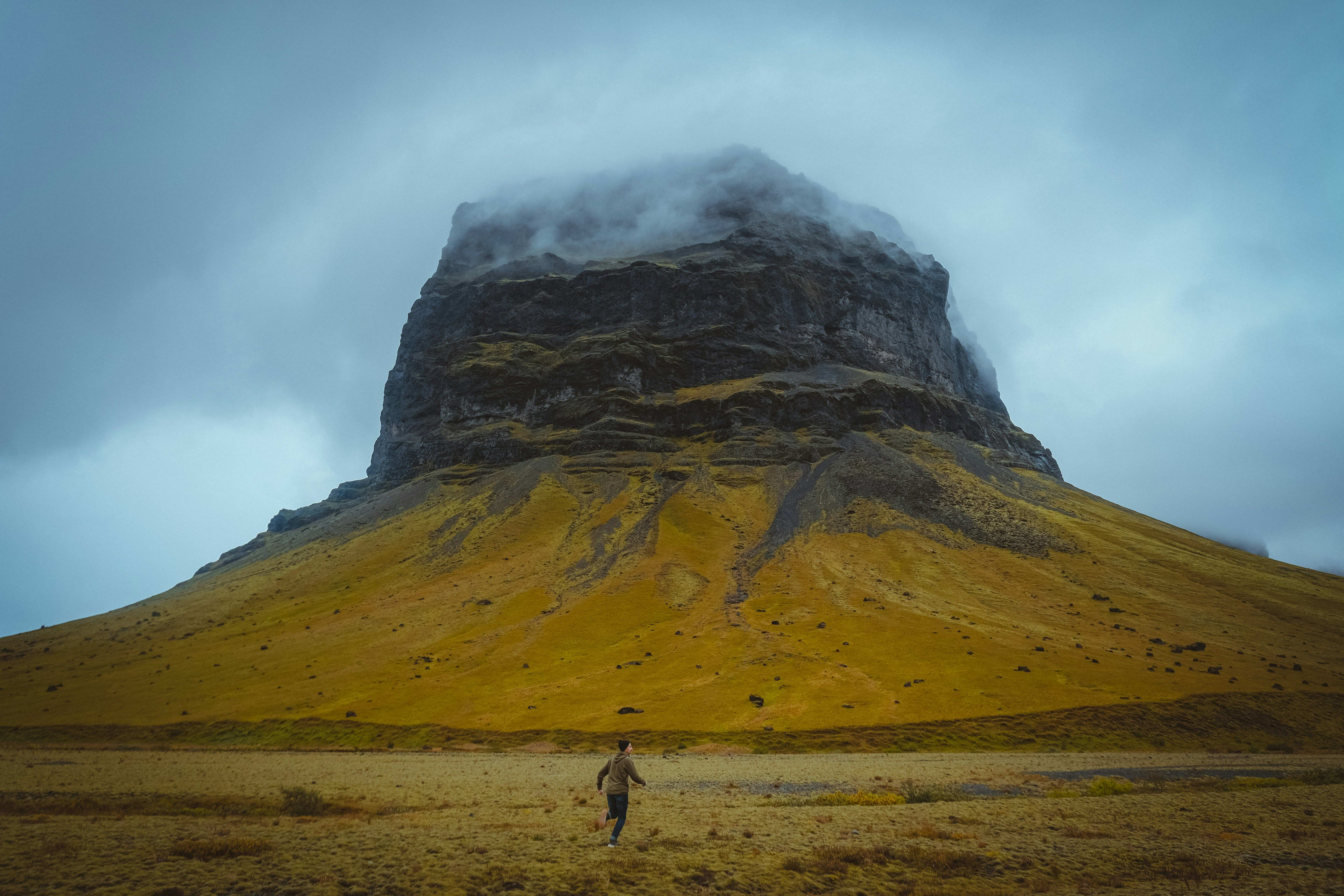
6. 冰岛平顶山峰:Lómagnúpur山
Lómagnúpur山坐落在冰岛南岸1号环岛公路沿线,靠近瓦特纳冰川国家公园,被誉为冰岛南部的一大地标。这座山高约690米,是一座玄武岩山峰,平坦的峰顶看上去很是独特。Lómagnúpur山历史悠久,至少有100多万年的历史,而底下的熔岩和沉积物层,更是有约250万年的历史。长年累月的火山喷发和冰川侵蚀造就了Lómagnúpur山,它是研究冰岛地质的重要基地,因此Lómagnúpur山也被称为冰岛地质史的活化石。
Lómagnúpur山与冰岛中世纪名著《尼雅尔萨迦》(Njáls saga)紧密相关。《尼雅尔萨迦》记载了10世纪末冰岛家族相互角逐的历史,展现了当时冰岛社会的文化传统和价值观。比如,当时有位名叫Flosi Þórðarson的冰岛家族首领,为了帮自己的家族报仇雪恨,徒步穿越Lómagnúpur山区。Lómagnúpur山还是一座“守护山”,据说山中栖息着名为 Jón the Giant 的巨人,他是这片土地的守护者,保护着附近居民不受外来者侵害。有些当地人自称在山的周围看到过神秘的光芒或听到过低沉的声音,猜想这是守护者在与外界沟通。

Lómagnúpur山悬崖陡峭,直插天际,视觉效果拉满,尤其是在阳光或雾气笼罩时,格外震撼。Lómagnúpur山还是海鹦和北极燕鸥等鸟类的栖息地,徒步或驻足时常能观赏到这些活泼的鸟类在悬崖间盘旋。Lómagnúpur山坐落于冰岛南岸平原,周围平坦的地形与陡峭的山峰形成鲜明对比,让人惊叹于大自然的鬼斧神工。
交通方式
If you're driving from Reykjavik, you can head east along Iceland's Ring Road (Route 1), passing through the towns of Selfoss and Vik. Lómagnúpur is located west of Skaftafell, about a 4-hour drive away. There is parking at the foot of the mountain. In the summer, there are buses from Reykjavik to Vatnajökull National Park, passing by Lómagnúpur, which is suitable for tourists who don't want to rent a car.
Photography skills
Lómagnúpur Mountain is photogenic in all weather conditions. At sunrise or sunset, the sunlight shines obliquely on the mountain, creating warm-toned, three-dimensional images. On foggy days or when shrouded in thin clouds, the photos take on a cool and mysterious feel. If you prefer wide shots, use the plains opposite the mountain as the foreground to capture the entirety of Lómagnúpur. For close-ups, position yourself near the foot of the mountain, using the steep cliffs as the main subject to emphasize the mountain's majestic grandeur. You can also utilize reflections – after rain, capturing the mountain's reflection in puddles creates a unique and striking effect.
If you're looking to explore the mountains of southern Iceland and are better off driving through the country, check out these carefully selected packages: