Class F highway definition
In Iceland, F-roads refer to "mountain roads," typically located in the central inland highlands and other remote areas. The "F" in F-roads stands for "Fjall," meaning "mountain" or "highland" in Icelandic. These roads are generally narrower and more rugged than well-maintained main roads (such as Iceland's Ring Road), often consisting of gravel roads. Some sections even include steep inclines, mud, and river crossings. Therefore, most F-roads do not allow two-wheel drive vehicles; four-wheel drive (4WD) vehicles are required for a smooth and safe journey. Furthermore, due to the complex and varied road conditions, experienced drivers are essential, and a high level of concentration is necessary. Novice drivers are advised against attempting these roads.
F-class highway opening hours
Iceland's F-class roads are typically open during the summer months (approximately June to September), with opening hours depending on local weather conditions. During winter, most F-class roads are impassable due to snow and ice accumulation.
Driving Precautions on Class F Highways
F-class highways have complex road conditions, and drivers should be cautious when driving:
(1) There are very few gas stations, restaurants and emergency facilities along Class F highways, so you should prepare in advance and bring enough food, water and fuel. Since most Class F highways are located in remote mountainous areas, you can also buy or rent satellite positioning equipment if possible to prevent being trapped in the mountains in case of emergencies.
(2) Iceland's climate is unpredictable. Before you go, it is recommended to check the real-time weather forecast ( weather forecast website ) and road condition information ( Iceland road condition website ), and use GPS navigation or maps ( map website ) to find a suitable route.
(3) Obey traffic rules, be careful of wild animals crossing the road, and when you encounter wild animals, approach them slowly and do not disturb or injure them.
(4) Many F-class roads pass through famous Icelandic attractions and hiking trails. When visiting these places, you should also abide by local regulations and protect the ecological environment.
(5) When driving on F-class highways, it is generally necessary to rent a car ( Iceland Summer Self-Drive: The Best Way to Explore Iceland ). Most car rental companies' rental insurance does not cover damage to cars caused by gravel. It is recommended to ask whether the insurance includes this clause when renting a car to reduce possible losses.
(6) Iceland has long hours of sunshine in summer, and in June it can be almost 24 hours a day. It is recommended to bring a pair of sunglasses to reduce the damage of sunlight to your eyes.
(7) The speed limit on main rural roads in Iceland is 90 km/h, and the speed limit in urban areas is 50 km/h. The speed limit on F-class gravel roads is 80 km/h, and the speed limit is 30 km/h in some areas.
(8) Camping must be carried out in specific areas. If you have camping plans, it is recommended to find out the designated campsites along the F-class highway in advance.
F-Road River Crossing Guide
In Iceland, the vast majority of F-class roads cross rivers, requiring drivers to ford water. It's fair to say that without these rivers, 95% of F-class roads would be much easier to drive on. Improper fording can damage vehicles and, in extreme cases, even endanger lives, so the following precautions should be taken:
Do not drive directly into the water. It is recommended to get out of the vehicle first to observe the river and find the shallowest crossing point. Generally speaking, the shallowest crossing point is not in the calmest part of the water, but in an area where you can see the rocks on the riverbed. Some rivers have ropes, which are markers for the shallowest crossing points; you can use the ropes to cross the river. When crossing, it is recommended to use the 4x4 mode of a four-wheel drive vehicle, driving slowly at the highest second gear at approximately 10 km/h. Maintain a constant speed and do not stop or shift gears to prevent the car from stalling in the river.

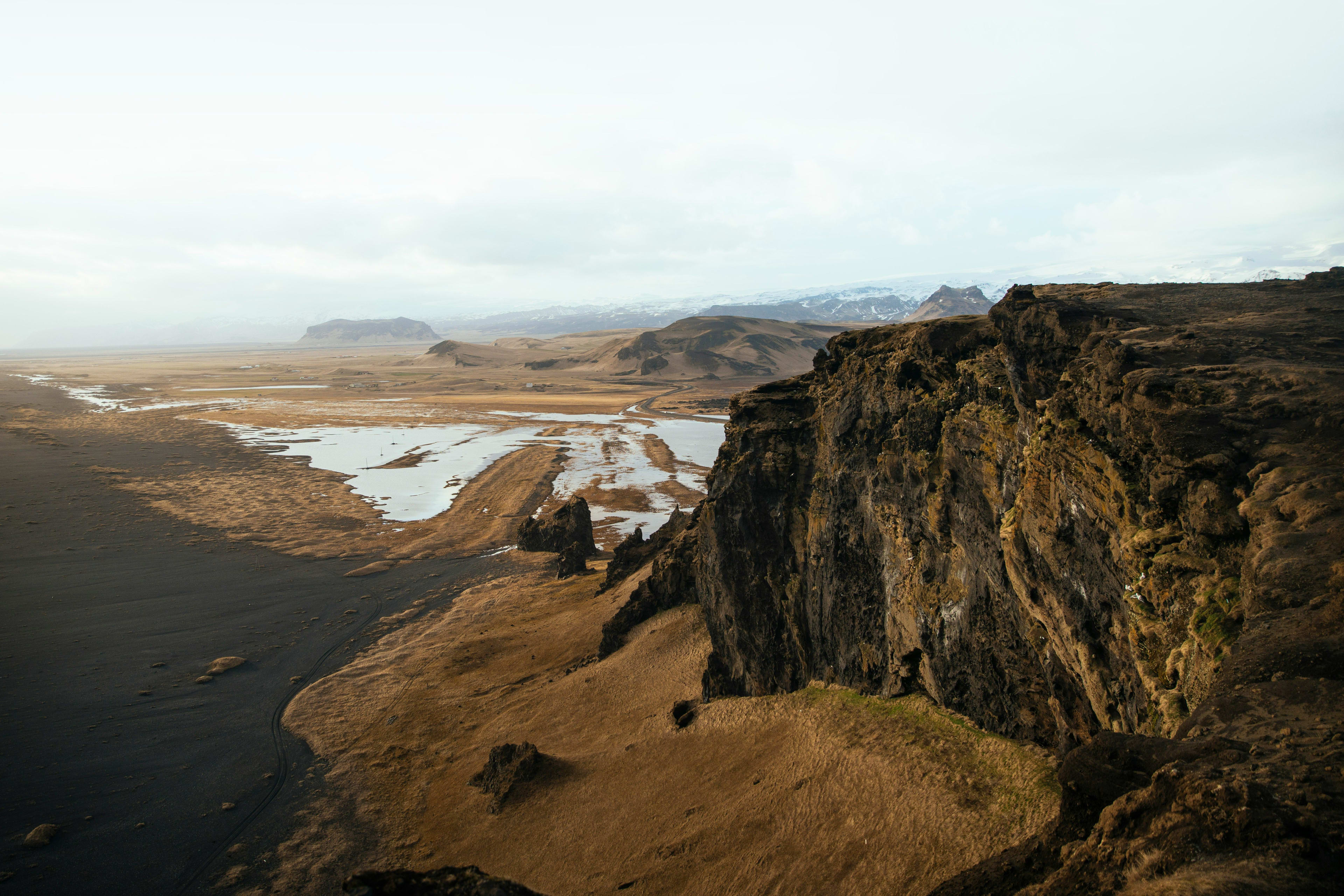
Iceland's famous F-class highway
Having learned about the basic information about Iceland's F-class roads, here are some introductions to some of Iceland's famous F-class roads.
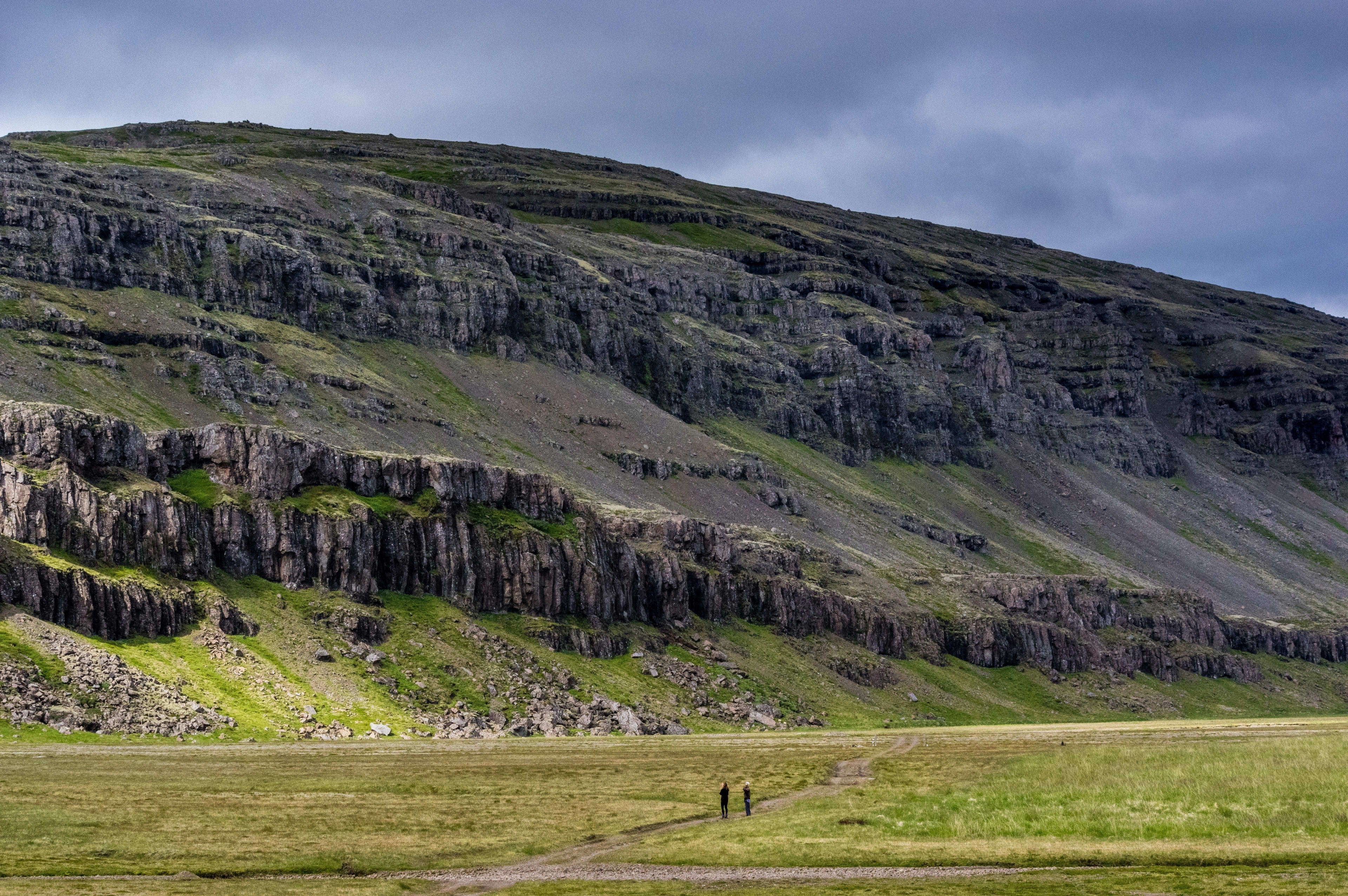
Highway F26 - Sprengisandur Road (Sprengisandur)
F26 is one of the longest F-class roads in Iceland. It connects the area around Akureyri in the north (near Lake Mývatn ) with the area around Hella in the south (near Hofsjökull, meaning "temple glacier"), and is approximately 156 kilometers long. Iceland has two north-south F-class roads; F26 is one of the more challenging, the other being F35 (Kjalvegur or Kjölur).
F26 is a rugged and desolate road with no shops, gas stations, or even cell phone signal at times. The only campsite along the route is the Nyidalur cabin beside the Hagakvisla River. The Hagakvisla River is the most difficult section of the entire road to traverse. The river's water level is unpredictable; normally a medium-sized river, it deepens and becomes more turbulent during heavy rains, increasing the risk of crossing (F26 may even be closed if the water level is too high). Therefore, to ensure safe passage across the river, it is recommended to drive a medium to large four-wheel drive vehicle.
The F26 highway passes through many diverse landscapes, including desolate black deserts, volcanic areas, and rugged mountains. It also features two beautiful waterfalls: Aldeyjarfoss (for more off-the-beaten-path Icelandic destinations, see: Lesser-known Icelandic travel spots ) and Hrafnabjargafoss. If you're willing to take a longer route, you can also visit Dynkur and Búðarhálsfoss waterfalls, as well as the secluded and tranquil Vonarskarð hot spring area.
Although the scenery along Highway F26 is not as spectacular or diverse as other F-class highways, the only challenge is crossing the Hagakvisla River. Overall, the road is relatively smooth and comfortable to drive on.
Highway F35 - Kjölur (Kjalvegur)
F35 is Iceland's second longest F-class road, also known as the Kjölur or Kjalvegur road. Unlike most F-class roads in Iceland (which cut into the central inland highlands from the surrounding lowlands and require a return trip), F35 traverses almost the entire length of Iceland from north to south. Compared to another F-class road that runs through northern and southern Iceland—F26—F35 is less difficult to drive, but it is more congested, mainly because it passes by many famous Icelandic attractions, such as Hveravellir thermal springs, Kerlingarfjöll volcano (meaning "Old Woman Peak"), Hvitarvatn (White Lake), Hofsjokull glacier, and Langjokull glacier .

Historically, F35 was an important horse trail in Iceland, playing a crucial role in trade and communication. Residents of northern Iceland also used this route to travel to Þingvellir in the south to attend parliament. Today, Þingvellir is a national park, forming the famous Golden Circle with attractions such as Gullfoss ( a classic Golden Circle day trip: visiting geysers, Gullfoss, and Þingvellir National Park ), Geysir, and others . Starting from southern Iceland, F35 begins at Gullfoss. Driving along the Golden Circle route (Route 35) to Gullfoss, continuing north, Route 35 becomes F35, and the smooth road turns into a gravel road. The entire F35 journey takes about 5 hours. After reaching Syðri-lángamyri, turn onto Route 731, then switch to Route 1, which leads to the town of Blönduós in northern Iceland .
Highway F35 passes by many scenic spots. If you don't mind taking a longer route, you can switch to Highway F347 along the way and follow the roadside signs to Kerlingarfjöll (the area was designated a nature reserve in 2017). There is a resort (Kerlingarfjöll Mountain Resort) near the scenic area, which provides catering and accommodation services for travelers along the way. Camping here does not require reservations, but if you want to stay indoors, you must make a reservation in advance. Near the resort is the natural hot spring Hveravellir (of course, if you want to know which Icelandic hot spring is best for you, you might want to check out the most worthwhile Icelandic hot springs to experience ). This is a geothermal area in the Icelandic inland highlands (Knowledge about Icelandic geothermal activity: Iceland with surging heat: Exploring the wonders of Icelandic geothermal activity ), located between Hofsjokull and Langjökull glaciers. The famous Hveravellir hot spring is located in this area. The water temperature of the hot spring remains between 30°C and 40°C all year round. Surrounded by rocks, you can enjoy the surrounding rolling mountains and vast plains while soaking in the hot spring pools. The open view is especially charming at sunset or during the aurora season.
Highway F35 has no sections that cross water, and even when it does cross rivers, it can be crossed via bridges, which is one of the reasons why it is easier to travel than Highway F26. Highway F35 passes the famous Hvitarvatn (White Lake), a pristine glacial lake formed by glacial meltwater from the Langjökull glacier. Hvitarvatn is a nesting ground for many birds, offering opportunities to observe a wide variety of species, admire the surrounding majestic mountains, and even experience glacier hiking at Hofsjökull and Langjökull glaciers ( Exploring the Wonders of Ice: A Complete Guide to Glacier Hiking in Iceland ).
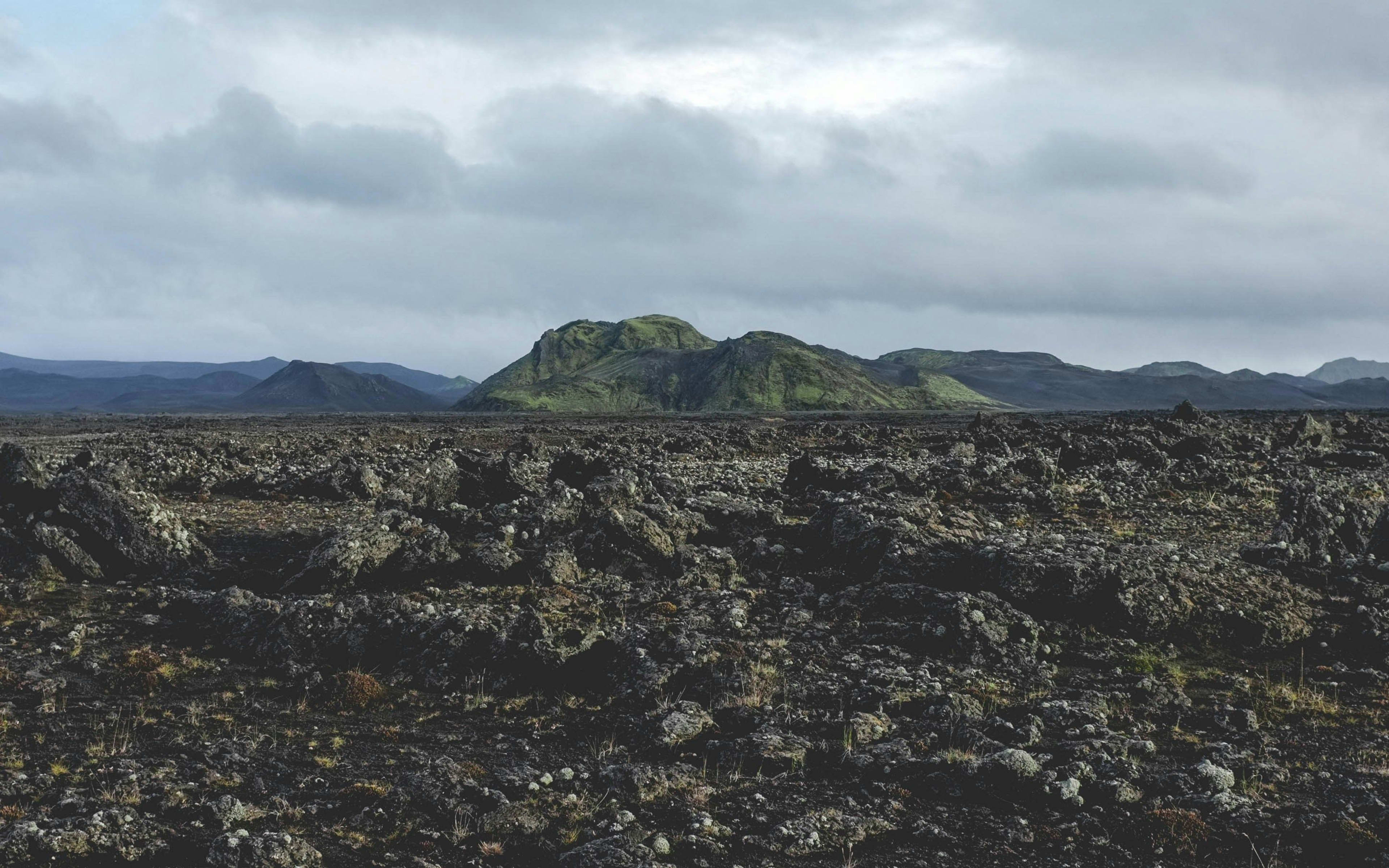
F88 Highway - Öskjuleið
Iceland's F88 road, also known as Öskjuleið or Askja Road, is a highway leading to the Askja volcano in the central inland highlands of Iceland. This road connects Iceland's Ring Road (Route 1) to the Askja volcano, crossing two major rivers. When river levels are low, the F88 is the fastest route to Askja. However, during heavy rains, the river depth can exceed 1 meter, so small vehicles are not recommended. If you plan to visit the Askja volcano but don't have a large enough vehicle or are unsure of your driving skills, the F910 road is recommended. If you plan to drive across rivers, a large four-wheel drive vehicle or a high-clearance jeep equipped with a snorkel is best. Note that there are no gas stations along the F88 road; the nearest gas stations are located near Lake Mývatn and Egilsstaðir , so it is advisable to bring sufficient fuel.

The F88 highway ends at Askja volcano, one of the most famous volcanoes in inland Iceland. Nearby is Öskjuvatn volcanic lake, formed after an eruption of Askja—one of Iceland's deepest lakes, with deep blue water and clearly visible volcanic rock formations along its shores. In the Öskjuvatn volcanic lake area is also a small thermal lake, Víti, meaning "hell." The thermal water in the Víti crater has a comfortable temperature, and many tourists enjoy soaking in the volcanic lake. Drekágil, another wonder near Askja volcano, features uniquely shaped volcanic rock formations that have been eroded by weathering, creating patterns resembling dragon scales—a truly fantastical sight.
The F88 highway also passes by Herðubreið volcano, Iceland's "Queen Mountain," a uniquely shaped volcano with a flat, table-like top. Herðubreið rises approximately 1682 meters, surrounded by flat lava desert. While its climb is extremely difficult, making it impractical, the view from the F88 highway is enough to appreciate its grandeur. At the foot of Herðubreið lies an oasis—Herðubreiðarlindir—where springs gather, creating a vibrant wetland surrounded by lush grasslands and vegetation. Historically, this oasis served as a supply depot for Icelandic travelers and herders, and also as a hiding place for some Icelandic fugitives.
Highway F208- Fjallabaksleið Nyrðri
Highway F208 consists of two F-class highways, one to the north and one to the south. The famous landmark Landmannalaugar serves as the boundary, with the northern section known as F208 North and the southern section as F208 South.
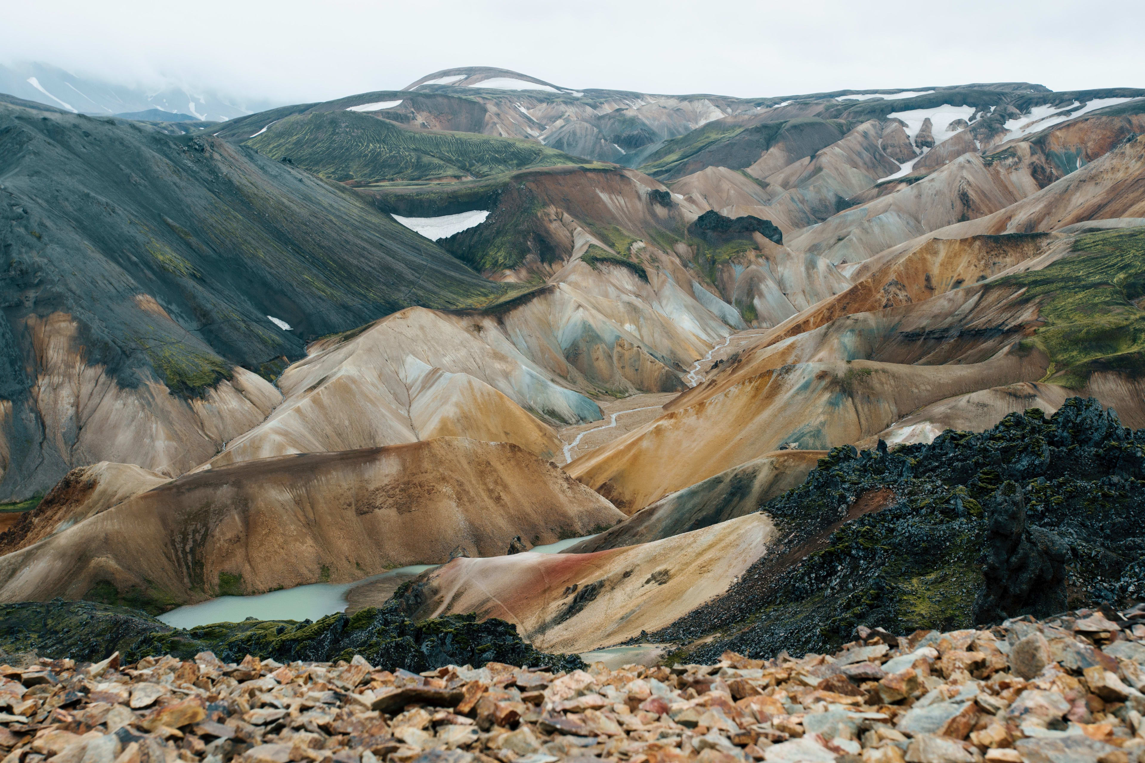
F208 North and F208 South are two distinct highways. F208 North connects Þjórsárdalur and Landmannalauka, offering views of glaciers, vast plains, and numerous waterfalls such as Sigoldufoss and Tungnaárfellsfoss. F208 South connects Landmannalauka and the town of Vik , boasting diverse landscapes and rolling mountains, making it a very pleasant route. In terms of driving difficulty, F208 North is a bumpy, gravel road, but it doesn't require crossing rivers, making it easier to drive. F208 South, however, is not only south of Iceland but also difficult, possessing almost all the challenges of Iceland's F-class highways: narrow, potholed, covered in gravel and sand, geographically remote, and requiring crossing several deep rivers (reaching depths of approximately 40-60 centimeters in summer). Although F208 South is more challenging, as one of Iceland's most beautiful highways, it is definitely worth exploring.
Landmannalauka, the dividing point of the F208 north-south highway, is itself a scenic spot. Located near the famous Hekla volcano, the Landmannalauka mountains are composed of various volcanic rocks containing different minerals such as iron, sulfur, copper, and magnesium. These minerals reflect sunlight in different colors, creating a rich tapestry of hues including red, yellow, green, and purple. Hekla volcano and geothermal activity have sculpted Landmannalauka's ever-changing landscape, showcasing craters, lava flows, and geothermal geysers. Furthermore, Landmannalauka offers numerous hiking trails, the most famous being the route from Landmannalauka to Þórsmörk , a journey of approximately 4-5 days that offers views of colorful mountains and soothing hot springs along the way.
Due to the challenging driving conditions on the southern section of F208, it is recommended to choose a medium or large four-wheel drive vehicle with as much ground clearance as possible to ensure safety when wading through water. It is also advisable to purchase appropriate rental insurance when renting a vehicle.
F338 Highway - Skjaldbreiðarvegur
F338, also known as Skjaldbreiðarvegur, is located in southwestern Iceland. It starts from F550 (near Lake Brunnavatn) and extends westward to F35, with a total length of about 51 kilometers.
Highway F338 is typically only open during the summer (late June to early September). It passes numerous attractions, including the Skjaldbreiður volcano and Gullfoss waterfall. A section of F338 runs along a power line, starting at Skjaldbreiður and extending westward, crossing a stream. This section has only a short stretch of sandy terrain; the rest is relatively easy to drive. Continuing along the power line, near Gullfoss waterfall, you'll encounter a deeper river. For added safety, you can switch to F333 and cross the river via the bridge near the geyser.
F338 is located in the Icelandic highlands and is not recommended for beginners. You should drive at least a mid-sized four-wheel drive vehicle. The route crosses two rivers, so the higher the vehicle's chassis, the better. Because the road is remote, cell phone signal may be unstable and there are few passing vehicles. If your vehicle breaks down, it will be difficult to get help. Therefore, you should make full preparations before setting off.
Highway F910 - Dyngjufjallaleið (West) & Austurleið (East)
Like F208, F910 also consists of two sections: the eastern section is called Austurleið, and the western section is called Dyngjufjallaleið. F910 connects to F88 and is an important road connecting the Askia volcano, but the route to Askia is generally via Austurleið. Dyngjufjallaleið has a longer total distance than Austurleið because, in addition to connecting to Askia, it extends into the central highlands, connecting to F26 in the west. Austurleið is of moderate driving difficulty, with two medium-sized rivers of moderate depth that are relatively easy to cross; a medium-sized four-wheel drive vehicle can safely pass through. Dyngjufjallaleið is more difficult to drive than Austurleið, with very rugged terrain. The central section also involves crossing several medium-sized rivers, the largest of which is about a 30-minute drive from the Nyidalur region and requires a large four-wheel drive vehicle. Furthermore, Dyngjufjallaleið is located in the central highlands, far from surrounding villages. In case of emergencies along the way, it is difficult to seek help. Therefore, it is essential to assess the driver's experience and vehicle condition and make thorough preparations before setting off.
Dyngjufjallaleið passes through the Nyidalur region, located near Vatnajökull National Park and close to the Fjallabak Nature Reserve. It's an ideal starting point for hiking, offering options such as the Laugavegur trek (a classic route from Landmannalaukar to Þórsmörk, passing colorful mountains and snow-capped glaciers) or the Fimmvörðuháls trek (a scenic route passing numerous waterfalls and craters). Explore the surrounding landscape.
Iceland's inland highlands are perfect for hiking, and this guide to beginner hiking trails will give you an overview!
F985 Highway - Jökulvegur
Highway F985 is located in the eastern highlands of Iceland, connecting Iceland's Ring Road (Route 1) with Skálafellsjökull (a branch of Vatnajökull, Iceland's largest glacier). The entire route is approximately 15 kilometers long and takes about 30 minutes. While Highway F985 appears short on a map, it actually features many zigzag bends and climbs steadily along a gravel road from the lower coastal elevations, lengthening the journey. Highway F985 is a vital route from the eastern coast to Vatnajökull , and some tour groups even offer direct jeep or snowmobile rides to the glacier for a convenient visit.
Highway 985 is only open during the summer. However, the road passes by many beautiful sights. Driving on Highway 985, you can not only appreciate the towering grandeur and pristine beauty of Vatnajökull Glacier, but also admire unique volcanic landscapes. If you're lucky, you might even spot adorable wildlife such as caribou and Arctic foxes.
Highway F985 does not require crossing rivers, but because the road is steep and narrow with many zigzag bends, and there is a risk of large trucks suddenly appearing from corners, as well as strong winds, it is necessary to check the weather conditions in advance and drive carefully.
Highway F839 - Leirdalsheiðarvegur
F839 is a highland road in northern Iceland, leading to the northern coast. Adjacent to the island of Flatey and near Eyjafjörður near Akureyri, F839 is a beautiful valley road offering thrilling F-class highway experiences and stunning sea views. There are also designated campsites and fishing areas along the coast. Part of F839 runs through the Icelandic highlands, and its opening hours are typically late July to early August due to weather and snowfall. The entire journey takes approximately 45 minutes. Like F839, F899 is another F-class highway in northern Iceland extending to the coast, but it is longer (F839 is 27 kilometers long).
F839 is a beautiful mountain road, with rugged mountains, snow-capped peaks, and winding rivers stretching out beside you, offering breathtaking scenery. The valleys along the road were once inhabited, but due to frequent extreme weather events such as heavy snow and storms, crops could not be grown. Encouraged by the Icelandic government, many indigenous people moved away from the valleys, which remain uninhabited to this day. Therefore, when traveling along F839, it is essential to carry sufficient supplies in case of emergencies.
Highway F839 passes through several small and medium-sized rivers, so it is recommended to drive a medium-sized four-wheel drive vehicle.
F939 Highway - Öxi
F939 is a shortcut in southeastern Iceland from Djupivogur to Eijlstad (related reading: A Must-Visit Retreat on the Icelandic Ring Road: A Travel Guide to the Eastern Fjords ). Compared to other ring roads, F939 takes less time. The 18-kilometer-long F939 is a steep, gravel road that winds its way up the mountain, with many potholes, narrow sections, and frequent sharp turns. Although the speed limit on this gravel road is 80 km/h, it is still recommended to drive slowly to avoid tire blowouts caused by gravel friction and potholes. Be wary of oncoming vehicles and flying gravel that could damage your car.
Highway F939 passes by Hænubrekkufoss and Foldafoss waterfalls. Starting from Dópivogul, head north onto F939, and you'll soon see Foldafoss. While not as famous as Iceland's Gullfoss or other waterfalls, Foldafoss is a powerful and majestic waterfall, a rare example of wild natural beauty in eastern Iceland. After passing Foldafoss, you'll see Hænubrekkufoss, where the water cascades down the rock face in multiple tiers, creating a curtain-like effect reminiscent of a waterfall plunging thousands of feet. The surrounding rocks are covered in moss, and the lush green grass adds to the charm.
Highway F643 - Strandavegur
Highway F643, also known as Strandavegur, is located in the Hvalfjörður fjord region of western Iceland. This F-class highway leads to remote areas of western Iceland and is quite rugged, accessible only to four-wheel drive vehicles. Compared to other famous F-class highways, F643 is shorter, but offers unique scenery and a higher driving difficulty, making it suitable for adventurous drivers. Situated inland in the Hvalfjörður fjord region, it traverses rugged mountains and desolate valleys, with gravel roads and steep, narrow mountain sections.
Driving along F643, you can admire the mountains, rivers, and waterfalls surrounding Hvalfjörður fjord and experience the unique wilderness of western Iceland. F643 is close to Glymur Waterfall, once one of Iceland's tallest waterfalls and a popular hiking destination. You can hike along the canyon trails, enjoying the waterfall and surrounding natural scenery; the entire route takes approximately 3-4 hours.
Experienced travelers or those looking for a challenge can join the Iceland Ring Road self-drive package , embarking on a 10-day or 12-day romantic summer Ring Road self-drive tour of Iceland , giving them more time to explore the magic and beauty of Iceland.